Marine GPS/AIS Chartplotter
Model : KP-122A/122B
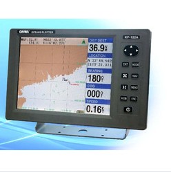
The KP-122A is an advanced built-in Class B AIS Transponder(or Receiver) GPS Chartplotter with a SBAS receiver designed for coastal ships, fishing boats and pleasure craft. The powerful processor performs highspeed processing of position fixing and augmentation using SBAS correction. It comes with an easy to use chartplotter which stores up to 84,000 track points. This compact and cost-effective unit offers extremely accurate position fixes.
Specifications of KP-122A/122B
Plotter Characteristics
1. Display : 12” (247mm x 186mm), 800 x 600, Color TFT LCD
2. Waypoints : Up to 18,000 waypoints, including the optional logo, or as geographic information
3. Routes : Up to 50 routes (300 waypoints for each route)
4. Tracks : 40 Tracks including 1 real-time track record and 39 history track records. 2,100 points for each track, 84,000 points in total. The information of each point including time, location and direction
5. Marks : Up to 99 kinds of marks for various objects
6. Alarms : Anchor , XTE , Arrival , Next WPT, Impact, PDOP
7. Charting System : K-chart
8. Chart Scale : 0.006~ 380nm
GPS Characteristics
1. Satellite Receiver Type : 50 Channels, GPS L1 frequency, C/A Code
2. Horizontal Position Accuracy :
Autonomous < 2.5 m,
SBAS < 2.0 m
1. Velocity Accuracy : 0.1m/s
2. Heading Accuracy : 0.5 degrees
3. Time-To-First-Fix :
Cold Start (Autonomous) : 32 s
Warm Start (Autonomous) : 32 s
Thanks. We will reply you within 12 hours.
susan----sales003 (at) huayang-tech.com
Model : KP-122A/122B
The KP-122A is an advanced built-in Class B AIS Transponder(or Receiver) GPS Chartplotter with a SBAS receiver designed for coastal ships, fishing boats and pleasure craft. The powerful processor performs highspeed processing of position fixing and augmentation using SBAS correction. It comes with an easy to use chartplotter which stores up to 84,000 track points. This compact and cost-effective unit offers extremely accurate position fixes.
Specifications of KP-122A/122B
Plotter Characteristics
1. Display : 12” (247mm x 186mm), 800 x 600, Color TFT LCD
2. Waypoints : Up to 18,000 waypoints, including the optional logo, or as geographic information
3. Routes : Up to 50 routes (300 waypoints for each route)
4. Tracks : 40 Tracks including 1 real-time track record and 39 history track records. 2,100 points for each track, 84,000 points in total. The information of each point including time, location and direction
5. Marks : Up to 99 kinds of marks for various objects
6. Alarms : Anchor , XTE , Arrival , Next WPT, Impact, PDOP
7. Charting System : K-chart
8. Chart Scale : 0.006~ 380nm
GPS Characteristics
1. Satellite Receiver Type : 50 Channels, GPS L1 frequency, C/A Code
2. Horizontal Position Accuracy :
Autonomous < 2.5 m,
SBAS < 2.0 m
1. Velocity Accuracy : 0.1m/s
2. Heading Accuracy : 0.5 degrees
3. Time-To-First-Fix :
Cold Start (Autonomous) : 32 s
Warm Start (Autonomous) : 32 s
Thanks. We will reply you within 12 hours.
susan----sales003 (at) huayang-tech.com
Certificate
- CE
Main Products
Marine Radar , isatdock, fish finder, GPS chart plotter